Welcome to our new web site!
To give our readers a chance to experience all that our new website has to offer, we have made all content freely avaiable, through October 1, 2018.
During this time, print and digital subscribers will not need to log in to view our stories or e-editions.
Most of Missouri has transitioned out of drought conditions for now, said University of Missouri Extension state climatologist Zack Leasor.
“The past two months have brought abundant …
This item is available in full to subscribers.
We have recently launched a new and improved website. To continue reading, you will need to either log into your subscriber account, or purchase a new subscription.
If you had a login with the previous version of our e-edition, then you already have a login here. You just need to reset your password by clicking here.
If you are a current print subscriber, you can set up a free website account by clicking here.
Otherwise, click here to view your options for subscribing.
Please log in to continue |
|
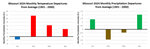
Most of Missouri has transitioned out of drought conditions for now, said University of Missouri Extension state climatologist Zack Leasor.
“The past two months have brought abundant rainfall to most of Missouri,” Leasor said. “After back-to-back drought years in 2022 and 2023, drought concerns were high in early 2024 following warm and dry conditions in February and March.”
Conditions took a turn for the better in April, he said. Statewide precipitation was 6.01 inches, 2.04 inches above the monthly average, making April 2024 Missouri’s 15th-wettest April back to 1895, based on preliminary data from the National Oceanic and Atmospheric Administration. Several locations in western Missouri received just over 10 inches of rainfall during April. At the end of April, year-to-date precipitation in Missouri was 12.87 inches, 1.58 inches above average. The wet and warm pattern continued into the first half of May.
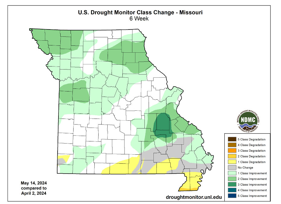
Soil moisture recharge and improvements to streamflow have been significant, Leasor said. On April 1, 58% of the U.S. Geological Survey monitoring gauges in the state recorded at least below-normal streamflow (< 25th percentile); that number dropped to 1% as of May 15.
“Agricultural drought impacts have been absent, but the timing of rainfall early in the growing season has made planting and planning fieldwork difficult,” he said. “Groundwater has been slower to recover after several years of dry conditions, but there have been improvements since April.”
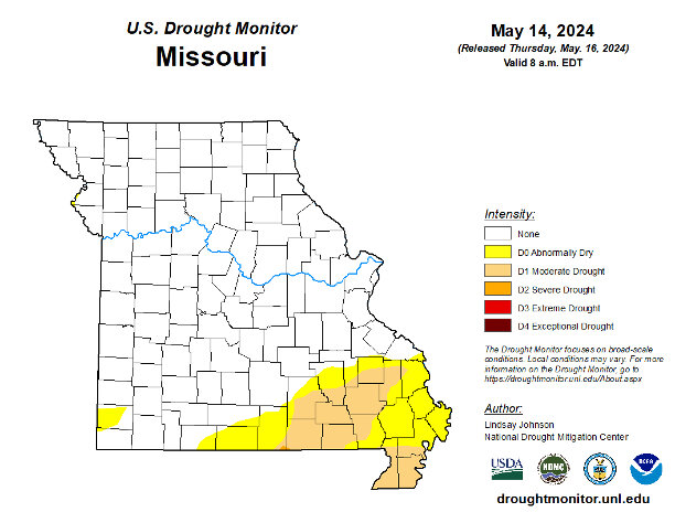
The May 14 update from the United States Drought Monitor shows that only 17.98% of Missouri is currently classified as either abnormally dry or in moderate drought; these locations are in southern and southeastern Missouri.
This active weather pattern was expected to continue through the end of May, and the Climate Prediction Center forecasts a higher probability for above-average precipitation during June.
“forecasters are monitoring a shift from El Niño to La Niña conditions in the Pacific Ocean,” Leasor said. “Cooler ocean temperatures during La Niña conditions have an impact on atmospheric circulation, and while there is significant uncertainty in long-range forecasts, warmer and drier summertime conditions have been observed in the central U.S. during previous La Niña events.”
Missouri Gov. Mike Parson recently continued the state’s drought alert to Sept. 1, and Missouri’s Drought Assessment Committee will continue to monitor conditions over the summer.


Comments
No comments on this item Please log in to comment by clicking here